
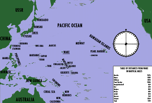
In the same latitude as the island of Hawaii, Wake lies slightly north of a line from Pearl Harbor to Saipan, at about four-sevenths of the distance. Unlike the groups of atolls in the Marshalls and Carolines, Wake is isolated. Pokaakku atoll, in the Marshalls, is 304 miles south-southeast, and the nearest Japanese base of importance, Kwajalein, was 639 miles to the southwest. For additional distances to adjacent friendly or hostile bases, see the strategic map [printed within the end piece].
Deep water surrounds the entire atoll. Seaward sides of the atoll barrier reef are steep-to.
Wake atoll itself is a barrier reef which varies in width from 30 to 1,100 yards. It is widest at the open, northwest end and narrowest along the southern side, where its width averages less than 100 yards. The underwater section of the reef is free of loose material but has occasional potholes and large coral boulders. Off the southern coast, the reef has the usual characteristic fissures running perpendicular to the shoreline.
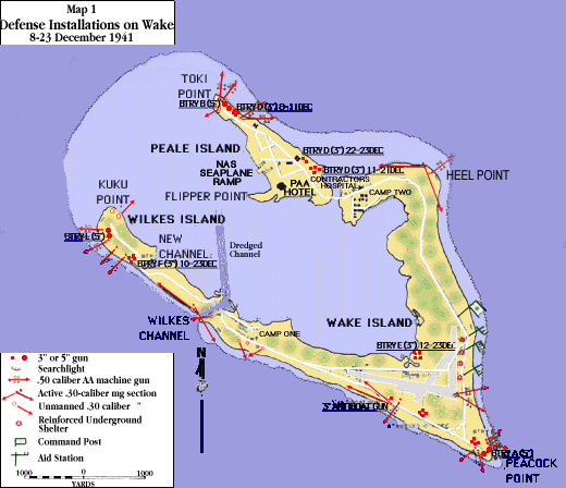
Three passageways open into the lagoon: (1) the open northwest end of the atoll, (2) the opening between Peale and Wake Island, and (3) the channel between Wilkes and Wake Islands. No break opens the reef between Peale and Wake Island, and Wilkes channel was the only possible entrance for vessels.[2] The western opening, between Peale and Wilkes, is some 2,275 yards wide. Peale channel has a width of 58 yards at the seaward entrance and narrows to 51 yards between the two bridges spanning it. The distance from bank to bank between Peale and Wake Island is about 115 yards. Wilkes channel is from 37 to 48 yards wide. From bank to bank the distance is 48 to 52 yards. Approximately 4 miles long with an average width of 1 1/5 miles the lagoon has an area of 3 1/2 square miles. It varies greatly in depth within short distances and has many near-surface and protruding coral heads and much foul ground. The eastern end is more shallow, and large sections with the hollow of V-shaped Wake Island appear as tidal flats at low water.
The beaches are of white coral sand. At many places along the shore line they are strewn with jagged coral rocks and king-size boulders, some "large as a 5-ton truck."[3] Beaches vary in width from 20 to 170 yards, but average 100 yards. The narrowest beaches are located on the north coast. Beach slope is quite gradual. Natural terraces or embankments exist only along the north coast (except
along the south shore of Wilkes). At the coast line, or vegetation line, there is frequently a moderate rise in elevation. Exits from the beaches are available at all points.
A heavy surf roars continually against the northeast (windward) reef. The atoll is large enough to provide a lee in any weather and there is therefore much less surf on the southern (leeward) side, but heavy surf occasionally runs on the southeast end of Wilkes Island during periods of heavy swell and rough sea. The boom of the surf is never silent on Wake, and actually reduces the range and acuity of hearing of persons in any part of the atoll.
Inside the lagoon, the mean tide range is about 1 1/2 feet and the low waters have a stand of 2 or 3 hours.
The surface of the three islands is a smooth roll of disintegrated coral, interspersed with boulders, which are most numerous on Wilkes and the southern leg of Wake Island where they range to 5 or 6 feet in diameter. Maximum elevation on the atoll is 21 feet, with an average of 12 feet. Three "high" points with elevations of more than 20 feet are to be found: (1) at Heel point, (2) on the seaward side of Peale Island about 500 yards from Toki Point, and (3) on the lagoon side of Wilkes Island some 750 yards from Kuku Point. The outside, seaward face of Wake Island, maintains a fairly uniform elevation of approximately 18 feet, with a gradual slant to the center of the island and then to the lagoon side. Due to the porous soil, drainage is good, too much so in fact, so that no natural water supply is available.
Trees, thick tropic shrub growth (often with thorns), and grasses are scattered through the islands and provide much opportunity for natural concealment. Vegetation is densest on the south leg of Wake Island, west and south of the airfield. Trees sometimes reach a height of 20-25 feet, but the towering coconut palms found on most atolls are missing.
There is no wide variation in temperature. Yearly maximum is 95º, minimum, 68º. Mean monthly temperatures run from 76º to 83º. Rainfall is light, averaging 33 inches for the year. The wettest season is from July through October.
Wake lies in the belt of the northeast trade winds, and more than 50 percent of the wind observations range from east to northeast during all seasons of the year. Average cloud coverage for the year is approximately 0.5, or 40 percent, being heaviest during late summer and early fall, with cumulus clouds predominant.
From a military defender's point of view, especially that of a Marine defense battalion, several aspects of Wake's 1941 terrain are of preeminent importance:
First, the triangular shape and division of the atoll into three islands, which accords closely with the triangular organization of a defense battalion.[4] In one sense an advantage, this three-way compartmentation could also work against the defense by preventing ready concentration of force at any point while assisting an enemy to inflict defeat in detail. Hardly less disadvantageous would be the problems imposed by inter-island communications.
Second, the extensive total coast line which must be defended by any garrison. Although relatively small in net area, Wake has an exterior shore line in excess of 10 miles, and a lagoon shore line of almost that length. To cover the entire 21-mile perimeter would be out of the question, even for a full-strength defense battalion.
Third, the dense vegetation, with few fields of fire and many possible concealed approaches.
In some cases, especially before any enemy landing could be effected, this brush would provide valuable shelter and concealment, but should battle be joined on the ground the vegetation of Wake would be an ally to the attacker.
Finally, the continual roar of the surf, besides being a mere annoyance to individuals, could mask hostile sounds such as the movement of troops through the thickets, or the sound of approaching bombers.
[2] Dredging of this channel and of a turning basin within the lagoon was one of the major prewar projects for development of Wake. In late 1941, the channel had been partially dredged to 20 feet but the basin was not completed.
[3] Colonel Bayler's description.
[4]
For a discussion of the organization and composition of the Marine defense battalion, see
note 4, page 2.
 Return to
HyperWar: U.S. Marine Corps in World War II
Return to
HyperWar: U.S. Marine Corps in World War II
Return to
HyperWar: World War II on the WorldWideWeb
Compiled and formatted by Patrick Clancey